The excavator bucket bites into the clay-rich till that underlies much of Blackburn, revealing a clean vertical face for logging. An exploratory test pit gives your team a direct look at soil stratification, groundwater seepage, and buried obstructions—something a borehole simply cannot match. In Blackburn, where glacial deposits alternate with sandstone bedrock from the Millstone Grit series, visual inspection of each layer is essential for foundation design. We dig to depths of up to 4.5 m where safe, logging every horizon against BS 5930. Before backfilling, we often combine this with a plate load test to verify bearing capacity at formation level, and we always check for the presence of sulfate-bearing soils that could attack concrete in this region.
A test pit reveals what no borehole log can: the actual fabric and moisture condition of each soil layer in Blackburn's glacial till.
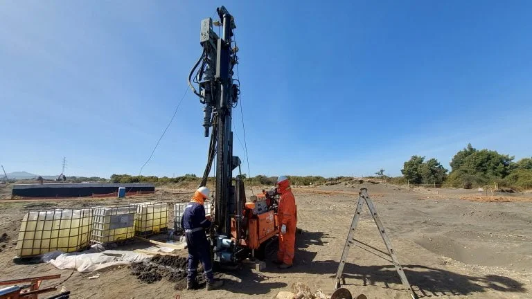
Technical details of the service in Blackburn
Procedure video
Risks and considerations in Blackburn
A common mistake on Blackburn projects is trusting a single SPT borehole to characterise a site underlain by glacial till. The till here is far from uniform—sand lenses, clay bands, and isolated cobbles can produce misleading blow counts. Without an exploratory test pit, you risk designing footings on a layer that appears competent on paper but collapses under load due to hidden soft zones. We have seen cases where a £600 pit saved £15,000 in remedial piling. The pit gives you the ground truth that desk studies and even CPT profiles cannot guarantee, especially in the complex drift geology of this part of Lancashire.
Our services
Each exploratory test pit program is tailored to Blackburn's ground conditions. We offer three core services to match project stage and budget.
Visual Logging & In-Situ Description
A chartered geotechnical engineer logs every pit face to BS 5930, photographing key horizons and recording groundwater strikes. The description covers soil type, colour, structure, consistency, and any anthropogenic inclusions. You receive a factual report within 48 hours, ready for foundation design.
Undisturbed Block Sampling
For projects requiring laboratory shear strength or consolidation parameters, we extract hand-cut block samples from the pit walls. These are sealed in wax and transported to a UKAS-accredited lab for triaxial and oedometer tests. This approach preserves the soil's true fabric and moisture content better than tube samples.
Backfill & Compaction Certification
After logging and sampling, we backfill each pit in 250 mm layers using the excavated material or imported granular fill. Each layer is compacted with a vibrating plate and tested with a nuclear density gauge to achieve 95% MDD per BS 1377-4. A compaction certificate is issued for your site records.
Common questions
How deep can an exploratory test pit go in Blackburn?
Most pits are excavated to 3.0 – 4.5 m, limited by excavator reach and ground conditions. In Blackburn's glacial till, we rarely exceed 4.5 m due to the risk of side-wall collapse. Deeper investigations require a trench box or shoring, which we can arrange if the project demands it.
What is the typical cost for a test pit in Blackburn?
A standard exploratory test pit including logging, sampling, and backfill typically ranges from £410 to £630, depending on depth, number of samples, and access constraints. Bulk discounts apply for multiple pits on the same site.
How do test pits differ from boreholes in glacial till?
Boreholes give a 100 mm diameter window into the ground; test pits open a full excavation face. In Blackburn's boulder clay, test pits reveal cobble layers, sand lenses, and soft clay pockets that a borehole may miss. They also allow visual inspection of groundwater seepage paths and root penetration.
Do I need a test pit if I already have a desk study?
Yes. A desk study identifies potential hazards but cannot confirm actual ground conditions. Blackburn's drift geology is highly variable—a map may show 'till' but the reality could be laminated clay or peat-filled channels. A test pit provides the physical evidence that insurers and regulators expect under Eurocode 7.
What happens if we hit groundwater during excavation?
We record the depth of first water strike and the rate of inflow. If seepage is heavy, we install a temporary standpipe and monitor stabilisation over 24 hours. The data is included in your factual report so the drainage designer can plan dewatering or sump pumping accordingly.