Geophysics in Blackburn addresses the subsurface challenges posed by the local Carboniferous geology, including glacial till, Coal Measures, and potential mine workings. Our non-intrusive surveys provide critical ground models aligned with UK specification, particularly Eurocode 7 (BS EN 1997-2) and the requirements of the Coal Authority. Key methods include MASW / Vs30 for seismic site classification and determining shear wave velocity profiles directly applicable to seismic design, and seismic tomography for mapping rockhead and identifying voids or fractured zones ahead of foundation design.
These investigations are essential for residential developments on brownfield land, commercial structures requiring dynamic analysis, and infrastructure projects near historic mining corridors. The data supports foundation optimisation, earthworks verification, and risk mitigation for ground instability. Complementing the seismic techniques, we often integrate electrical resistivity to refine contamination or void detection, ensuring comprehensive site characterisation for planning approval and safe construction in the borough.
A plasticity index jump from 20 % to 40 % can double the swelling pressure under a slab in Blackburn’s clay-rich glacial till.
Technical details of the service in Blackburn
Risks and considerations in Blackburn
Blackburn sits at roughly 150 m above sea level on the western edge of the Pennines, where the bedrock is Carboniferous Millstone Grit overlain by up to 8 m of glacial till. That till contains highly plastic clay matrices that, when wetted beyond the plastic limit, lose shear strength rapidly. If the Atterberg limits are not measured early, the design might assume a stiff clay with a safe bearing capacity of 150 kN/m² when the actual plasticity index places it in the high-swell category. After a wet winter, the same clay can develop desiccation cracks, and the next rainfall event forces water into those cracks, triggering cyclic volume changes that crack ground-floor slabs and lift partition walls.
Our services
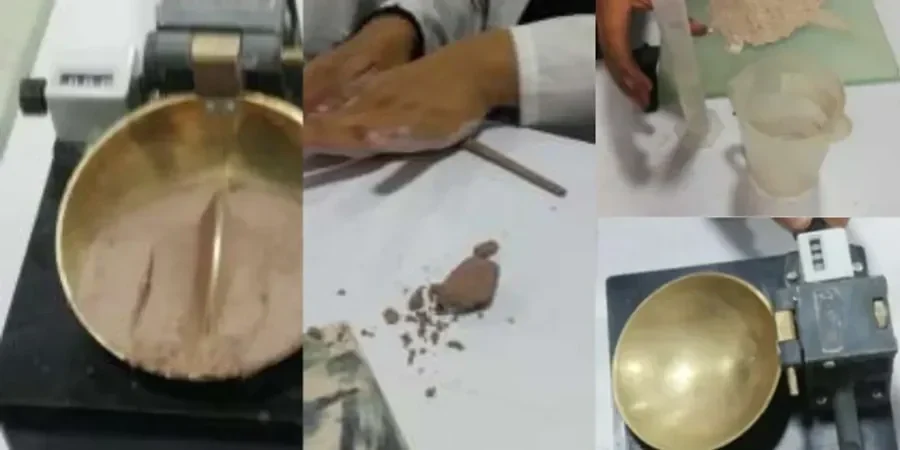
Our Blackburn geotechnical laboratory delivers a full range of index and classification testing services, all performed under UKAS-accredited procedures. Every Atterberg limit test is completed within five working days, with a detailed report that includes the plasticity chart, activity ratio, and correlation with expected volume change potential.
Liquid & Plastic Limit Determination
We measure the liquid limit using the BS cone penetrometer (80 g, 30° cone) and the plastic limit by rolling 3 mm threads. Results are plotted on the Casagrande plasticity chart to classify the soil as low, medium, high or very high plasticity. Typical turnaround is three days for a full set of limits.
Shrinkage Limit & Linear Shrinkage
For clays that will be used as fill or exposed to seasonal moisture changes, we determine the shrinkage limit and linear shrinkage ratio. This is critical for projects in Blackburn’s residential developments where clay heave can damage shallow foundations and driveways.
Plasticity Index & Activity Ratio
We compute the plasticity index (PI = LL – PL) and the activity ratio (PI / percentage of clay-size fraction) to predict swelling potential. A PI above 35 % in Blackburn’s glacial till indicates high shrinkage-swelling behaviour that requires deeper foundations or Improvement.
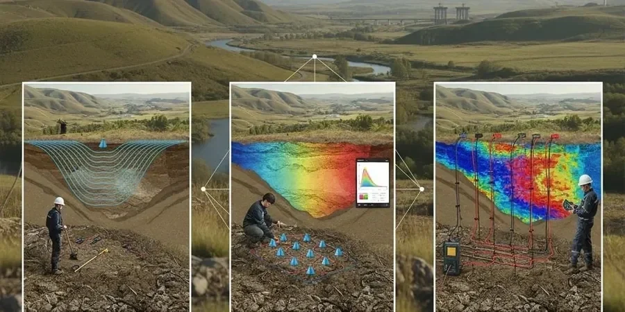
Geophysics in Blackburn provides a non-intrusive means of investigating ground conditions to support safe, cost-effective design and construction. The town sits on a varied geological succession dominated by Carboniferous Millstone Grit and Lower Coal Measures, often mantled by glacial till and post-glacial alluvium along the River Darwen corridor. These strata can conceal buried mine workings, solution features, and variable bedrock depths that pose significant geotechnical risk. A carefully designed geophysical survey, integrated with targeted ground investigation, identifies such hazards early, ensuring compliance with BS 5930 and the recommendations of the Coal Authority’s development risk guidance for former mining areas.
Our methodology applies proven UK standards to acquire high-resolution subsurface data across Blackburn’s challenging terrain. Techniques including electrical resistivity tomography, seismic refraction, and ground-penetrating radar are calibrated to local ground truth, typically provided by standard penetration tests or cone penetration testing. Cross-hole and downhole seismic surveys further quantify dynamic stiffness for foundation and earthworks design. All acquisition, processing, and interpretation follow the requirements of BS 5930:2015+A1:2020 and relevant Eurocode 7 parts, with deliverables aligned to the Specification for Geophysics in Engineering and Environmental Investigations published by the Geological Society.
Typical projects in Blackburn demand a refined understanding of subsurface complexity beneath residential, commercial, and former industrial land. Geophysics routinely screens for shallow mine entries and abandoned shafts beneath proposed housing developments, maps rockhead and weathering profiles under wind turbine bases on the Pennine fringe, and delineates sand and gravel lenses within glacial sequences for infrastructure drainage design. Where access permits, rapid profiling is supplemented by In-Situ such as dynamic probing or plate load tests to verify geophysical signatures. This layered approach reduces the volume of intrusive excavation and de-risks earthworks on brownfield sites where buried obstructions and contaminated ground are anticipated.
Upon completion, clients receive a comprehensive factual and interpretative report containing 2D/3D geophysical sections, contour plots of key horizons, and an engineering-geological model correlated with intrusive findings. The report explicitly maps anomalies warranting further attention, enabling focused follow-up by exploratory test pitting or rotary drilling. This integrated package empowers civil and structural engineers, developers, and local authority regulators to make confident decisions on foundation type, ground treatment, and remediation scope. By combining rapid areal coverage with high-resolution anomaly detection, our geophysics service in Blackburn reduces unforeseen ground risk, programme delays, and overall project cost.