Blackburn's position on the western edge of the Pennines creates a landscape where steep valleys and thick glacial till deposits dominate. A landslide assessment in Blackburn must account for this legacy of glacial and periglacial processes that left variable drift cover over Carboniferous millstone grit. Eurocode 7 (EN 1997-1:2004) and BS 5930 provide the framework for evaluating stability here, but local knowledge of drainage patterns and historical slips is equally critical. The mixture of boulder clay and laminated clays in the Darwen Valley, for example, demands careful investigation of shear strength parameters before any development proceeds. We routinely combine field mapping with subsurface exploration to build a reliable ground model, integrating calicatas exploratorias to expose soil profiles in accessible locations. This approach ensures that every assessment reflects the specific conditions of each site rather than generic assumptions.
Glacial till in Blackburn can lose up to 60% of its peak shear strength after a first-time slide, making residual strength testing essential.
Technical details of the service in Blackburn
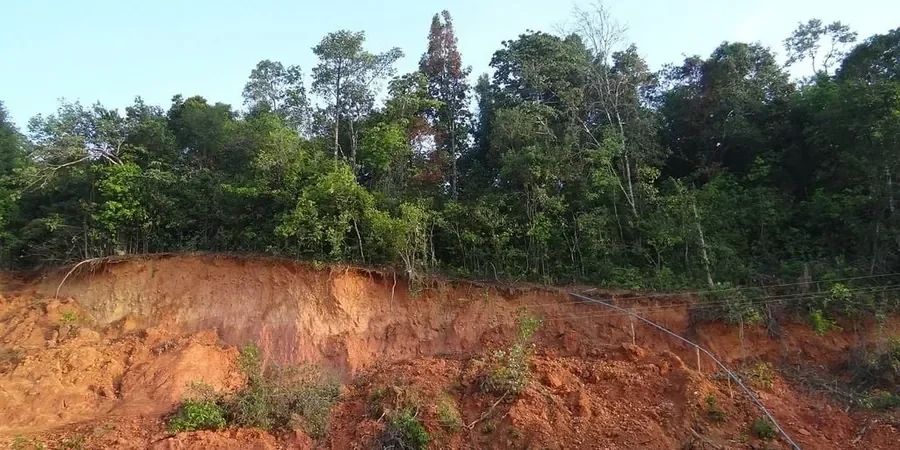
- Seasonal water table rise within the till, reducing effective stress along potential slip surfaces
- Presence of relict shear zones from periglacial solifluction, now reactivated by building loads
- Inadequate surface drainage diverting runoff onto the slope crest
The final design incorporated a cut-off drain and reinforced soil berm to achieve a factor of safety above 1.4 under worst-case saturated conditions.
Risks and considerations in Blackburn
Blackburn expanded rapidly during the Industrial Revolution, with terraces and mills climbing the valley sides without geotechnical understanding. That legacy means many older properties now sit on slopes that were cut or filled with little compaction, creating zones of incipient instability. Urban runoff from impermeable surfaces has altered natural drainage paths, saturating the glacial till more frequently than historic records suggest. Climate projections for East Lancashire indicate wetter winters and more intense summer storms, which will raise pore pressures faster. A proper landslide assessment in Blackburn must therefore look beyond the current geometry and consider how land-use changes and shifting rainfall patterns affect long-term stability. Ignoring these factors can turn a dormant slope into an active hazard that threatens both property and public safety.
Our services
We offer two complementary services tailored to the challenges of Blackburn's terrain, from initial reconnaissance through to detailed stability analysis.
Slope Instability Mapping and Risk Zoning
Field-based identification of active and relict landslide features using LiDAR interpretation, aerial photo review, and ground-truth surveys. Outputs include hazard zonation maps and a preliminary factor-of-safety assessment for planning applications in Blackburn's more sensitive valley districts.
Detailed Limit Equilibrium and Numerical Modelling
Advanced analysis using Slide2 or FLAC2D to model failure mechanisms in glacial till and colluvium. We calibrate models against site-specific shear strength data and groundwater monitoring, delivering design recommendations for stabilisation measures such as drainage, soil nails, or retaining structures.
Common questions
How much does a landslide assessment in Blackburn typically cost?
For a standard residential site of up to 0.5 hectares, the cost ranges between £720 and £2,800 depending on the complexity of the geology and the number of boreholes or trial pits required. Larger developments with multiple slope zones or deep failure surfaces will sit at the upper end of this range. We always provide a fixed quote after an initial site walkover.
What signs indicate I need a landslide assessment on my Blackburn property?
Look for cracks in brickwork that follow a stepped pattern, doors or windows that stick suddenly, tilting fence lines or retaining walls, and patches of damp ground on the slope that appear after dry weather. In Blackburn, these symptoms often appear on the clay-rich tills of the Darwen Valley or along cut slopes near the M65 corridor. Early assessment can prevent costly remediation later.
How long does a standard landslide assessment take from site visit to report?
For a straightforward site with good access, the field work typically takes one to two days, followed by laboratory testing on soil samples over two to three weeks. The analysis and report writing require another week. Total turnaround is usually three to four weeks, though we can prioritise faster delivery for urgent planning applications in Blackburn.