We recently sampled a residential site off Whalley Road where the contractor hit a stiff clay layer at 1.2 m that turned into a silty sand with gravel below 2.5 m. Without proper identification, the foundation design would have been over‑conservative for the clay and under‑designed for the sand. Our soil classification follows BS 5930 and the USCS system to match each stratum to its correct engineering behaviour. For shallow foundations on variable ground we always cross‑check with a plate load test to verify bearing capacity in each layer. The Blackburn area has a mix of glacial till and alluvial deposits along the River Darwen, so a single classification number rarely covers the whole plot.
A single USCS symbol can save thousands in unnecessary foundation depth when the clay cap hides a dense sand layer.
Technical details of the service in Blackburn
Risks and considerations in Blackburn
In Blackburn we often see thin layers of soft clay interbedded in the till that are missed during visual logging. If the soil classification does not capture these seams, the settlement calculation assumes a uniform material and the foundation may crack. Our lab splits every sample into its major and minor fractions, then runs separate classifications on each. A USCS dual symbol (e.g. CL/ML) flags the mixed behaviour. This is particularly important near the river corridor where alluvial silts alternate with till. Missing a low‑plasticity silt band in a predominantly clay profile can lead to differential settlement of up to 25 mm in a two‑storey structure.
This service complements our laboratory testing work for a complete project analysis.
Our services
We offer two complementary soil classification services tailored to Blackburn ground conditions.
Full USCS Classification with Atterberg Limits
Complete particle‑size distribution, liquid/plastic limits, moisture content, and USCS group symbol. Includes dual‑symbol analysis for layered till profiles. Turnaround 3–5 working days.
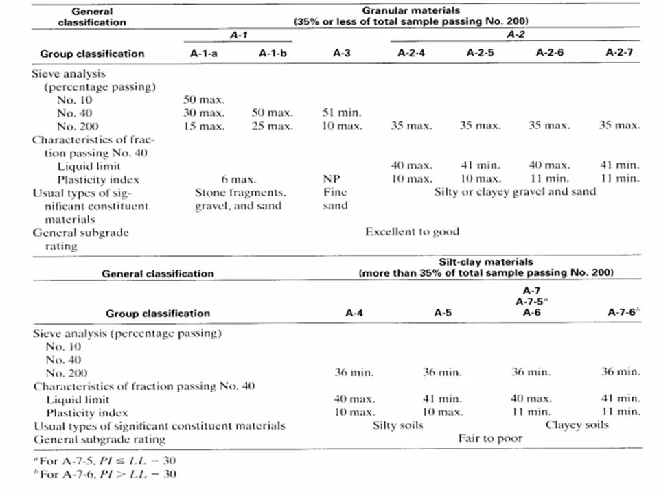
AASHTO Group Index for Pavement Design
Sieve analysis, plasticity indices, and group index calculation per AASHTO M145. Directly usable for CBR correlation and pavement layer thickness design. Same‑day sampling available for Blackburn sites.
Common questions
What is the difference between USCS and AASHTO soil classification?
USCS groups soils by particle size and plasticity (e.g. CL, SM), while AASHTO assigns a group index from A-1 to A-7 based on sieve analysis and Atterberg limits, primarily for pavement subgrade evaluation. Both are complementary – we often report both for Blackburn projects that involve both foundations and roadworks.
How much does a soil classification test cost in Blackburn?
A full USCS classification with Atterberg limits typically ranges between £50 and £80 per sample, depending on the number of tests required. Volume discounts apply for multiple samples from the same site. Contact us for a quote based on your specific scope.
Do I need soil classification for a small extension in Blackburn?
Yes. The glacial till in Blackburn can hide soft layers or pockets of silt that affect foundation depth. Even a single USCS classification helps the structural engineer confirm the assumed ground type and avoid under‑design. It is a low‑cost check that prevents expensive repairs later.